Lori Dengler | Return to Essentials with the 2026 Tsunami Drill
Understanding Tsunami Preparedness and the Importance of Awareness
The third week in March brings the spring equinox and Tsunami Preparedness Week. The North Coast has experienced two tsunami warning events in the past 15 months; the most recent tsunami in July caused significant damage to Crescent City’s Harbor. While the recent tsunami warnings may feel a bit like crying wolf to some, they highlight how our tsunami warning system currently works, areas for improvement, and, I hope, serve to increase awareness of a very real and serious threat.
Key Challenges in Tsunami Response
There are two big challenges when it comes to tsunamis: first, making sure people in the tsunami zone are notified and know how to safely evacuate, second, convincing everyone in safe areas away from potential inundation to stay where they are. Our outreach in the past has tended to focus on the former, but the last two tsunami events have underlined the importance of doing a better job of convincing people outside of tsunami hazard areas to stay put.
I get the concern people have to move, especially in our modern era of Wireless Emergency Alerts (WEA), and outdated tsunami warning center alerting protocols that result in a much larger area being placed in a Warning than is necessary. When you receive a loud squawk on your phone stating “You are in Danger,” it is natural to want to take action, especially when a trusted government source is telling you to do so. Now is the time to learn the basics of how the tsunami warning system works and what areas really are at potential risk. It will give you assurance on how best to respond the next time we get a WEA Warning.
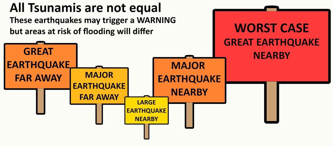
How the Tsunami Warning System Works
Our current tsunami warning protocol is one size fits all, but the tsunami reality is that a whole spectrum of events can trigger issuing a warning and many only pose danger to harbors, beaches, and very low-lying areas. The National Tsunami Warning Center in Palmer, Alaska, has developed a complex chart of potential earthquakes in the Pacific that would cause them to issue a warning for our coastline. They range from a very large earthquake far away to a similar-sized quake nearby and smaller quakes in between.
Historical Examples of Major Tsunamis
The March 1964 M9.2 earthquake in Alaska is a good example of a great earthquake coming to us from far away. It was the most damaging tsunami to strike California in the written historic era, claiming the lives of 14 Californians. Four significant surges were observed in Crescent Harbor and the water height crested at 21 feet above the low tide level. Water level at Trinidad was estimated to reach roughly 15 feet and waters swept logs and other debris from the Samoa Peninsula into the Bay. Fortunately, no structures were flooded and no injuries were reported in Humboldt County.
Other great quakes, such as the 1960 M9.5 in Chile and the 2011 M9.1 in Japan fall into the same category as 1964 — very large earthquakes with the potential to inflict great damage far away from the source area. Magnitude is related to the size of the earthquake fault rupture and the larger the area of sea floor deformation, the bigger the resulting tsunami. The actual damage caused is the result of several factors, including variation of slip along the rupture, fault angle relative to our coast, sea floor bathymetry and ambient tidal levels and no two tsunamis caused by earthquakes of similar magnitude will produce identical effects.
Earthquakes and Their Impact on Tsunami Potential
Earthquakes in the lower magnitude 8 range have also produced damaging tsunamis on our coast. In November 2006, an M8.3 earthquake in the Kuril Islands north of Japan produced a tsunami that destroyed half the structures in Crescent Harbor. The tsunami warning centers will place coasts in an alert status if modeling points to strong currents or possible flooding. Earthquakes centered far away have an important plus from a warning perspective. There is time to collect water height data from deep-ocean instruments and run forward models of the water height. A magnitude 8 earthquake is still very large, but its tsunami potential to produce a damaging tsunami on the far side of the Pacific is far less than earthquakes in the upper 8 to 9 range.
The tsunami potential of earthquakes centered close by is a much bigger problem for the Tsunami Warning Center to assess because the surges could reach us much more quickly. The 1992 M7.2 Cape Mendocino earthquake did produce a modest tsunami. It was recorded on tide gauges in California and Hawaii, and eyewitness accounts suggest about a 3-foot surge near Trinidad. Any earthquake with an initial magnitude estimate of 7.1 or larger will trigger a warning for all coastlines within ~150 miles of the source. For earthquakes of this size, only beaches and harbors are likely at risk, but there is a small chance that shaking could trigger a submarine landslide with localized but larger water heights.
The Cascadia Subduction Zone and Its Threat
Earthquakes in the low 7 range are not uncommon on the North Coast, and I estimate that if our current protocols were in place they would have triggered five warnings since 1980, and none causing damage. It might make you feel a little complacent about our potential for large local tsunamis. The Cascadia subduction zone extends from Cape Mendocino to Vancouver Island, Canada, and wasn’t recognized as a hazard until the late 1980s because it lay quietly sleeping producing no major earthquakes during the instrumental earthquake era. It took countless paleoseismology investigations to reveal the great tsunami of Jan. 26, 1700.
A repeat of the 1700 earthquake is our greatest tsunami threat because it is the same type of earthquake that produced the largest Pacific-wide tsunamis elsewhere and it is right beneath our feet. We won’t need an alert from a tsunami warning center to tell us something unusual is going on. The ground will shake for at least three minutes and probably longer. The ground around Humboldt Bay will deform, some areas sinking and others rising. Earthquake damage will likely knock us offline, effectively cutting communications to Palmer, other parts of the State, and to one another. First tsunami surges could arrive in minutes and continue for hours.
Preparing for the Future
Best estimates are that the 1700 earthquake was a M9 and ruptured the entire subduction zone from Humboldt County to southern British Columbia. The next Cascadia earthquake won’t be identical, and it might only rupture part of the subduction zone. A partial rupture could produce an earthquake in the lower to mid-8 range and produce very strong shaking from Humboldt to southern Oregon and a large tsunami in our area. It probably won’t impact northern Oregon to British Columbia as much as a full rupture, but for us, it might not be very different.
Whether a full or partial Cascadia rupture occurs, we won’t be able to tell the difference in the immediate aftermath. Both cases can cause major earthquake damage and cut us off from official guidance as to what to do. That means the shaking is your warning — and whether the earthquake is an 8 or a 9, you will notice it, and it will last a long time. All of California’s tsunami zone maps are based on the worst-case full Cascadia rupture and studying those maps now, on a quiet day without the stress of the ground shaking will allow you to plan your response.
Resources for Tsunami Preparedness
Our tsunami maps were compiled by the California Geological Survey and take the maximum modeled Cascadia tsunami, add on high tide, and put in another meter of elevation “factor of safety.” Learn more about the process at https://www.conservation.ca.gov/cgs/tsunami/maps. You can also use this site to figure out where your home, work, schools or other locations are compared to the tsunami zone. Printable maps are available for most North Coast communities at https://rctwg.humboldt.edu/tsunami-hazard-maps.
This Wednesday at 11 a.m. you should receive a text alert to practice responding to a large local earthquake from your county. To enroll in the notification system, search for the name of your county and emergency notification to sign up. The message will be brief, telling you that it is only a test, and a three-county evacuation drill has begun. Respond with a brief yes to note you have gotten the message.
No sirens, no civil air patrol, no one knocking on your door — what happens next is up to you. Take a moment to register whether you are IN or OUT of a tsunami zone. If you are in the zone, the county notification is your pretend earthquake and warning to head immediately to a safe area. DON’T DRIVE. Driving causes enormous traffic jams, even without shaking damage to roads. WALK to an area in the green area of the map or beyond the “Leaving Tsunami Zone” sign.
What will I be doing on March 25 at 11? I’ll pretend a great quake has just happened, lean over in my chair, and protect my neck with my arm — my knees won’t let me get under a desk anymore. After a minute or so, I’ll be “sheltering in place.” I live more than a mile away from any tsunami zones, so even in a worst-case Cascadia tsunami, I don’t need to leave the safety of my home even if I get a WEA alert that tells me to act.
Note: Free OLLI talk about the July M8.8 Kamchatka earthquake and tsunami is Monday, March 23 from noon-1:30 via Zoom https://www.humboldt.edu/olli/brownbag/july-29-2025-m88-kamchatka-earthquake-tsunami-tsunami-warning-system. More about the tsunami drill and other tsunami week activities at https://rctwg.humboldt.edu/tsunami-preparedness-week
Lori Dengler is an emeritus professor of geology at Cal Poly Humboldt, an expert in tsunami and earthquake hazards. Questions or comments about this column, or want a free copy of the preparedness magazine “Living on Shaky Ground”? Leave a message at 707-826-6019 or email Kamome@humboldt.edu.
- Latihan Soal OSN Ilmu Komputer SMA 2026 - June 1, 2026
- Latihan Soal OSN Kebumian SMA 2026 - May 31, 2026
- Latihan Soal OSN Geografi SMA 2026 - May 30, 2026
Leave a Reply