Meteorologist Warns: Two Major Storms Are Coming—Get Ready
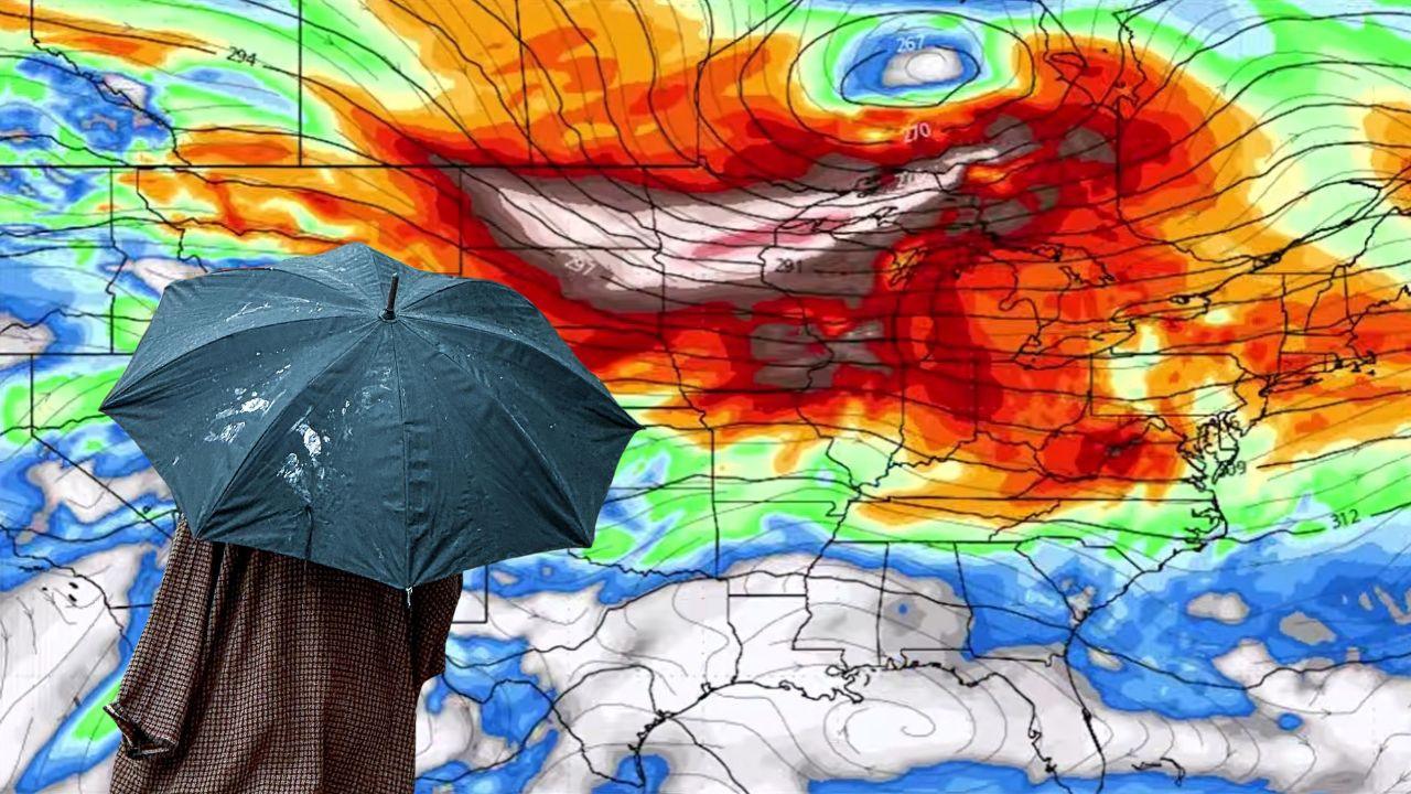
The Weather Map Is Changing Dramatically
The weather map is starting to look less like a spring forecast and more like a bar fight between seasons. In his latest video on Max Velocity – Severe Weather Center, meteorologist Max Schuster said a major pattern flip is underway, and he made clear that it is not some small, technical shift tucked away in the upper atmosphere. In his telling, it is the kind of change that reshapes nearly the whole country at once, spreading dangerous heat, setting up a new severe weather threat, and opening the door to even more active conditions later this week.
That is a lot to pack into late March. Schuster’s warning lands because it captures the mood of this pattern perfectly. One minute the country is dealing with cold shots and recent severe weather, and the next it is staring at a sprawling heat dome, another storm risk, mountain snow in some places, and hints that early April may come in swinging even harder. It is one of those forecasts that reminds you how quickly the atmosphere can change its mind.
A Heat Dome Is Rewriting The Map
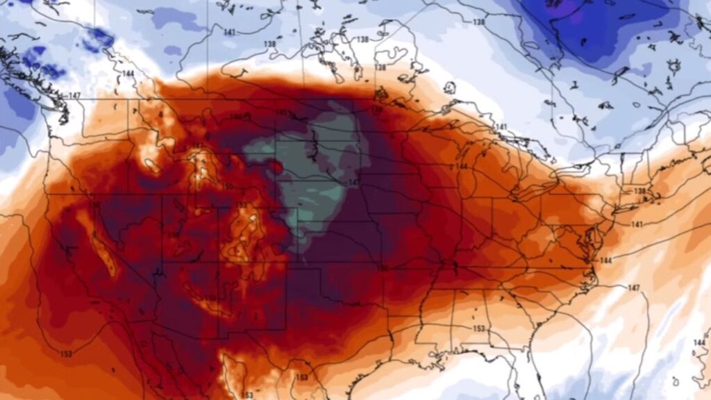
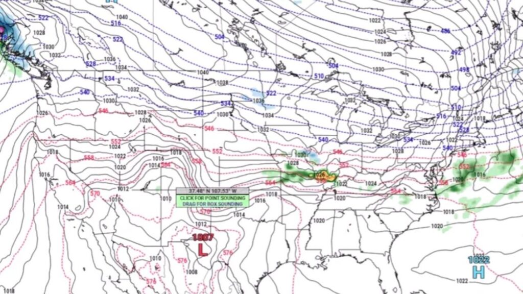
Schuster said the biggest driver right now is an intense ridge planted over the Desert Southwest, with the jet stream shoved unusually far north for this time of year. That kind of setup, he explained, is more typical of April or May. Seeing it this early is what makes the forecast feel so jarring. According to Max, this is not ordinary warm weather. It is the kind of early-season heat event that starts smashing records and making people question what month it is.

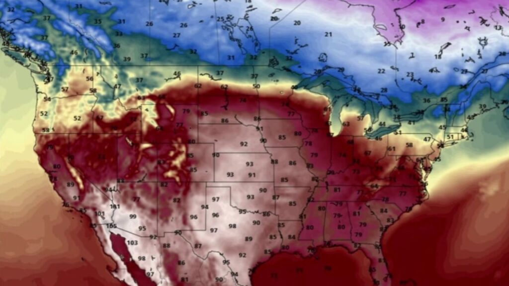
He said some areas near Phoenix and Mecca were approaching temperatures close to 110 degrees, which he described as mindboggling for March. That word fits. When a meteorologist who looks at weather maps all day says he has “never seen anything like this in the middle of March,” it gets your attention. Schuster said high temperatures are not just running above average. In some places, they are leaping far beyond old daily records, with some forecast highs coming in 10 to 15 degrees above the previous marks.
He said nearly 100 record highs were either expected to be tied or broken across parts of the Plains, Midwest, and Southwest, with even more records likely when low temperatures are counted. That may be the most fascinating part of this heat event. It is not only the afternoon highs doing the damage. The mornings are warm too.
Schuster noted that even the overnight lows in places like Wichita Falls and Oklahoma City were expected to stay in the low to mid-70s, while places as far north as St. Louis and even near Chicago could still wake up to readings in the 60s. In late March, that is wildly unusual. Warm mornings matter because they show how deeply the atmosphere has changed. A hot afternoon can sometimes happen under bright sun. A warm overnight tells you the whole air mass has shifted.
The Pattern Flip Brings Consequences
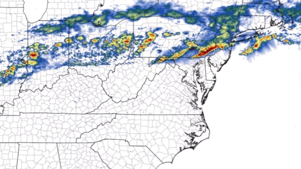
As Max Schuster laid it out, this is where the forecast turns from strange to dangerous. He said a low pressure system is expected to form in the Northeast, while a fairly strong cold front sweeps across the central Plains, Midwest, and Ohio Valley. That boundary will be the dividing line between the record heat and the colder air behind it, and that is where the atmosphere will try to cash in all that stored-up energy.
Schuster said that means a new severe weather risk is developing for Sunday.
The risk zone stretches from Illinois into the Mid-Atlantic, and while he repeatedly downplayed the tornado side of the forecast compared to the wind and hail threats, he did not dismiss it. He said the main concerns look to be very large hail and damaging winds, though a couple of tornadoes could still happen. That is an important point. A lot of people hear “lower tornado risk” and breathe easier, but a line of storms throwing large hail and damaging wind can still ruin a day in a hurry.
Hail can shred cars, crack windshields, punch up roofs, and flatten early spring vegetation. Straight-line wind can knock out power, topple trees, and hit broad areas fast. Schuster said he expects several storms, likely fairly widespread, especially Sunday afternoon and evening. He also floated the possibility that the tornado threat could still tick upward in later outlooks if the setup trends in a more favorable direction.
Two Different Storm Scenarios Are On The Table
One of the more useful parts of Schuster’s forecast was the way he broke down the severe weather uncertainty into two possible scenarios. In the first, storms would organize more quickly into a line, especially from around Columbus toward Pittsburgh. That kind of setup would favor a stronger damaging wind threat, with maybe a couple of tornadoes embedded within the line and some elevated hail risk farther west into eastern Illinois and western Indiana.
This is the more linear scenario, and Schuster seemed to lean toward it.
If that plays out, storms would likely become active after lunchtime and continue through much of the afternoon into the evening. In that case, the biggest issue would be a more widespread wind threat, with hail still in the mix but tornadoes staying more limited. The second scenario is the more eye-catching one.
Schuster said one model was showing nastier, more discrete storms firing as early as midday over places like Maryland and Delaware, with a greater hail threat and possibly a more elevated tornado risk. If that were to happen, the setup could become more serious in a hurry because discrete supercells are often the storms that can take better advantage of local pockets of instability and rotation.
Still, Max said he is more confident in the line-based outcome. That is a sensible call, but it also leaves a little tension in the forecast, and that tension is what makes the atmosphere so interesting right now. It is not a clean setup. It is one of those days where one small shift in storm mode can change the whole tone of the event.
The Northeast Stays Stuck In A Different Season
While the central and southern parts of the country deal with summerlike heat and the possibility of severe weather, Schuster said the Northeast is still stuck in something that feels much more like winter. He even acknowledged that people up there might be wondering what happened to spring, because from their point of view the weather still looks and feels cold enough to keep snow in the conversation. He said more snow could still be coming in parts of that region, which only adds to the bizarre cross-country contrast.
That split is one of the most striking parts of this whole setup. One side of the nation is sweating through record heat. Another side is still staring at a winter backdrop. That kind of mismatch is common in spring to some degree, but this feels especially exaggerated. It is also a reminder that weather pattern flips do not always mean everybody gets the same new season at once. Sometimes one region jumps into May while another region is still arguing with March.
The Quiet Break May Not Last Long
After the Sunday system moves through, Schuster said Monday and Tuesday should be quieter for most of the country. That does not mean completely quiet. He mentioned some snow in the Upper Peninsula of Michigan, isolated showers or storms in the Mississippi Valley, and another pounding for the Pacific Northwest with heavy rainfall and mountain snow by Tuesday into early Wednesday.
That western piece matters because it appears to be the seed for the next round.
Schuster said once that storm system moves into Montana, it should help spin up another strong storm around Wednesday and Thursday. Wednesday may stay mostly snowy on the Canadian side, but by Thursday the question becomes whether enough Gulf moisture returns northward to fuel another round of severe weather across the Midwest, Ohio Valley, and southern Plains.
That is where the forecast gets trickier. He said one model, the GFS, keeps the trough farther north and moving faster, which would limit the severe setup until later in the evening and make the whole thing messier. Another model, the European, is slower and a bit more organized, which could produce a cleaner severe weather risk by Friday, especially across the Ohio Valley.
In other words, there is not one locked-in answer yet. But Schuster’s message was still pretty clear: even if the late-week event does not match the bigger recent storms, it could still support hail, damaging winds, and tornadoes. That means nobody in the broad central-to-eastern corridor should assume the atmosphere is done once Sunday passes.
The Bigger Warning Is About What Comes Next
Maybe the most important part of Schuster’s forecast had less to do with the next 24 hours than with the bigger pattern taking shape toward the end of March and into early April. He said early April is still a long way out in forecast terms, but the large-scale setup already hints at a trough developing along the West Coast. In meteorology, that kind of signal often gets people’s attention because it can lead to stronger storm systems coming out into the Plains and central United States.
Schuster said that kind of pattern “always means big-time storms are coming.” That may be the line people remember most, because it suggests the current heat and storm risks are not isolated oddballs. They may be the opening act.
There is something undeniably striking about this whole stretch of weather. The country is being shoved from one extreme to another, with heat records falling, severe weather organizing on the edges of the warmth, snow still hanging on in the colder zones, and another system already lining up behind the first one. It is the kind of setup that makes spring feel less like a season and more like a test.
Why This Forecast Feels So Loud
What Max Schuster described is not just a hot spell or just a storm threat. It is a pattern full of whiplash. That is what makes it feel louder than a normal forecast. Record heat is impressive on its own. Add a cold front sharp enough to fire severe storms, then hint at another organized risk later this week, and suddenly the whole thing starts to look like a pivot point in the season.
The phrase “pattern flip” can sometimes sound technical and harmless, but in this case it is carrying real weight. Schuster’s forecast paints a country being stretched between seasons, with the atmosphere wasting no time cashing in on the chaos. The heat is arriving early, the storm chances are real, and the next few days could set the tone for what is ahead as March gives way to April.
So when he says get ready, it does not sound like hype. It sounds like a fair warning.


Leave a Reply