Arctic blast hits East Coast with drastic temperature drop as Lake Michigan grows ‘icicle claws’
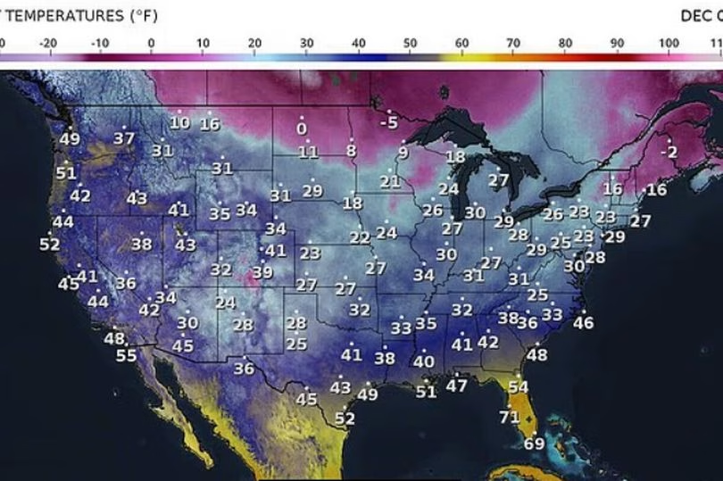

An arctic outbreak sweeping across the eastern half of the United States has sent temperatures plunging as much as 20 degrees below average along the East Coast, while parts of the Midwest and Great Lakes brace for several more days of bitter cold driven by a weakened polar vortex.
Meteorologists say the cold surge, which originated in central Canada, has expanded southward and will continue to impact millions through the weekend.
On Friday, temperatures in Flint, Michigan, fell to –3°F, breaking the city’s previous daily record of –6°F set in 1991, according to The Weather Channel.
By Saturday, below-freezing temperatures were expected across the Northern Plains and upper Midwest, with the Dakotas and surrounding states locked in single-digit and teen readings through the remainder of the weekend.
• Dangerous cold breaks records in New York as tri-state area slammed by snow blast
A viral video circulating earlier this week showed Lake Michigan coated in thick ice, with “icicle claws” draped over a pier as the arctic blast intensified across the region, MailOnline reports.
The cold stretch is forecast to persist into next week for major East Coast cities, including Philadelphia, New York and Boston, where strong winds will push wind chills even lower.
While wintry weather may linger in the Northeast for several more weeks, forecasters say warmer conditions are on the way for the Great Plains, with highs in the 50s expected as early as next week.
AccuWeather long-range meteorologists predict the arctic intrusions will continue into mid-December. Meteorologist Paul Pastelok said the polar vortex has remained weakened since November, allowing frigid air normally contained over the North Pole to spill southward.
He explained: “We are seeing the result as Arctic air pushes southward across the central and eastern U.S. in recent days and may continue to do so for the next couple of weeks or so in waves.”

A polar vortex forms when strong winds circulate in the stratosphere above the North Pole. When stable, the system keeps cold air confined to the Arctic. When disrupted, warm air moves northward and displaces cold air south.
AccuWeather forecasts two to three additional rounds of intense cold for the Midwest and East Coast through December 19, with even parts of central Florida at risk of frost.
Pastelok said the fast-moving nature of the cold air may limit the development of major snowstorms, though the best chance for East Coast snow will be around December 12. Portions of the Great Lakes, Ohio Valley and Appalachians could see a wintry mix around December 13.
Forecasters expect the cold pattern to ease before Christmas. In Minneapolis, temperatures over Thanksgiving dropped so low they fell below those recorded on Mars.


Leave a Reply